
Airspace closures across the Middle East following retaliatory strikes by Iran against Israel and the United States have led to thousands of cancellations, diversions and rescheduled flights. As a result, public interest in platforms such as Flightradar24 and FlightAware has increased significantly. The surge in traffic has highlighted the technology and data networks that enable real-time monitoring of global aviation.
Interest intensified further on Monday 2 March, when the first flights departed from the United Arab Emirates carrying stranded passengers home. Nearly 140,000 users tracked a single flight from Dubai International Airport to Mumbai. Tracking websites were also used to monitor footballer Cristiano Ronaldo’s flight to Spain from Saudi Arabia after the Iran conflict prompted a pause in AFC Champions League matches.
Assuming an average of 160 passengers per aircraft, that means more than 1.5 million passengers have been affected. https://t.co/POTE80XGUJ
— Flightradar24 (@flightradar24) March 2, 2026
Automatic Dependent Surveillance-Broadcast
The core technology used by most tracking platforms is Automatic Dependent Surveillance-Broadcast, known as ADS-B. Most commercial aircraft are equipped with ADS-B transponders that automatically transmit data including position, altitude, speed and identification.
These signals are broadcast at regular intervals and received by ground-based ADS-B receivers. The information is then transmitted to central networks operated by platforms such as Flightradar24 and FlightAware, where it is processed and displayed publicly in near real time.
Flightradar24 GPS jamming map shows how the GPS jamming in the Middle East has increased from February 27 to March 1.https://t.co/Ngz8eE1rlM pic.twitter.com/Pwpp0FpZ22
— Flightradar24 (@flightradar24) March 2, 2026
Flightradar24 operates what it describes as the largest receiver network globally, with around 50,000 ground stations worldwide. The network includes privately hosted receivers, and individuals can join free of charge if they are located in areas with limited coverage.
Satellite coverage and oceanic tracking
Ground receivers cannot capture signals beyond line of sight. To address this limitation, satellites equipped with ADS-B receivers are used to collect signals from aircraft flying over oceans and remote regions.
Satellite-based ADS-B has expanded tracking coverage significantly, particularly on long-haul routes where ground infrastructure is limited or unavailable.
Multilateration and older transponders
Not all aircraft rely on ADS-B. Some use older Mode S transponders that do not broadcast full positional data. In these cases, platforms such as Flightradar24 apply multilateration, or MLAT.
MLAT works by measuring the time difference of arrival of a signal from an aircraft at multiple ground receivers. For the calculation to be accurate, at least four receivers must detect the same signal. By comparing how long it takes the signal to reach each receiver, the system can determine the aircraft’s relative position.
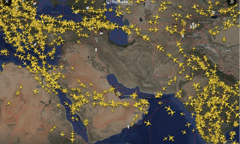
Global air traffic map with local conflicts clearly visible. pic.twitter.com/aTX7LoE25z
— Flightradar24 (@flightradar24) February 28, 2026
Because MLAT depends on multiple receivers, coverage can be limited in remote areas. It also requires aircraft to be above a certain altitude. As a result, flights may appear to disappear temporarily from tracking maps during take-off or landing.
Use of estimated positions
When ADS-B, MLAT and radar data are unavailable, tracking platforms may display estimated positions based on the aircraft’s filed route and destination. These estimates are clearly distinct from live positional data but allow continuity of display during gaps in coverage.
Yesterday vs Today (both 13:30 UTC) pic.twitter.com/hct7IJDcOD
— Flightradar24 (@flightradar24) February 28, 2026
GPS jamming and spoofing
Military activity can interfere with satellite navigation signals. GPS jamming involves transmitting signals on the same frequency as legitimate GPS signals, overwhelming receivers and preventing accurate positioning.
According to Flightradar24, GPS jamming in the Middle East has increased since the current conflict began. Similar interference has been reported during Russia’s invasion of Ukraine and by Israel in Gaza and Lebanon.
Interference can cause displayed flight paths to appear irregular, including zigzag or circular patterns. In addition to jamming, some aircraft may be affected by GPS spoofing, where false signals are transmitted to make an aircraft appear in a different location.
To mitigate these effects, tracking platforms rely on alternative data sources such as MLAT and cross-referenced receiver networks. However, in areas of active interference, positional data may remain incomplete or temporarily inaccurate.