


As climate change continues to intensify weather extremes, Cyprus is facing growing concerns over flood risks. Heavy rainfall events are becoming more frequent and severe, increasing the likelihood of both urban flooding and flash floods, which have historically caused the greatest damage on the island.
Recent incidents have highlighted the threat. During the storm of 29 August, emergency services received numerous calls, particularly in the Nicosia district, while forecasts point to an increase in heavy rainfall and extreme storms across Europe. Scientists have also warned that an exceptionally strong El Niño event could influence regional weather patterns, potentially affecting Cyprus.
EU framework for flood management
Recognising the need for a coordinated approach to flood risk management, the European Union adopted the Floods Directive (2007/60/EC), establishing a framework for assessing and managing flood risks.
In Cyprus, the Water Development Department (WDD) has implemented the directive through a structured process aimed at reducing the impact of floods on human life, public health, the environment, cultural heritage and economic activity.
Implementation of the directive involves three key stages:
- Preliminary Flood Risk Assessment (PFRA) for each river basin district, identifying areas where significant flood risks already exist or may emerge in future.
- Preparation of flood hazard and flood risk maps, illustrating potential consequences for people, infrastructure, the economy, heritage sites and the environment under different flooding scenarios.
- Development of Flood Risk Management Plans, coordinated at river basin level, for areas identified as facing significant flood threats.
Number of vulnerable areas rises to 43
As part of this process, the Water Development Department identified areas with heightened vulnerability to flooding.
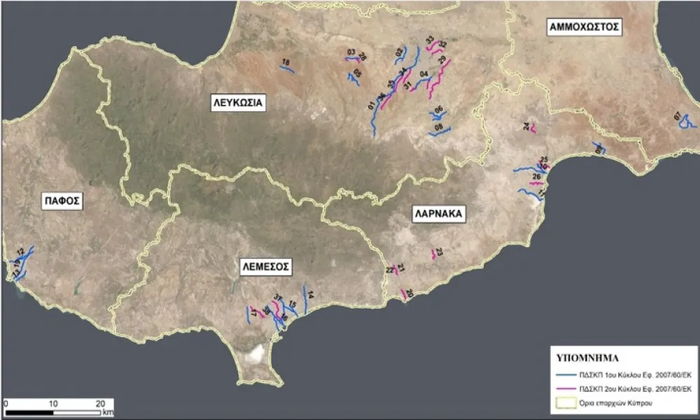
Initially, 19 Areas of Potential Significant Flood Risk (APSFRs) were designated. That number later increased by another 19, bringing the total to 38.
According to the department's Hydrology Service, five additional flood-risk areas were identified this month, increasing the total to 43.
Under the second Flood Risk Management Plan covering 2022-2027, these areas are spread relatively evenly across Cyprus' urban centres and do not include mountainous regions.
The majority are vulnerable to river flash floods, due to:
- Small catchment basins.
- Steep terrain.
- Sparse vegetation.
- Intense rainfall events.
- Short water concentration times.
Areas identified as being at significant flood risk
The following flood-risk zones have been identified, together with the associated river systems or waterways:
- Politiko to the Municipality of Nicosia - Pedieos River.
- Engomi and Agios Dometios - Klimos River.
- Kokkinotrimithia - Merika tributary.
- Strovolos and the Latsia industrial area - Kalogeros River.
- Paliometocho and Agioi Trimithias - Merikas River and the Koutis and Katouris tributaries.
- Dali industrial area - Almyros-Alykos system.
- Paralimni - inflow river and Paralimni Lake.
- Nisou, Pera Chorio and Dali - Gialias River.
- Ormideia - Ormideia River.
- Aradippou-Livadia - Archangelos-Kamitsis River and tributary.
- Kamares area of Larnaca - Kamares River.
- Mesogi, Paphos and Chloraka - Kosiinas River.
- Paphos town - Limnarka River.
- Germasogeia - Germasogeia River.
- Mesa Geitonia, Agios Athanasios and eastern Limassol - Vathias River and tributary.
- Polemidia and Limassol (Agios Antonios and Karnagio) - old and new courses of the Garyllis River.
- Ypsonas - Marketo stream.
- Astromeritis - Komitis River.
- Paphos town - Vasilikos stream in Paphos.
- Mari community - mouth of the Vasilikos River.
- Kalavasos community - Vasilikos River at Kalavasos.
- Kalavasos community - Asgata River.
- Agios Theodoros - Pentaschoinos River.
- Troulloi community - unnamed watercourse in Troulloi.
- Livadia municipal district - unnamed watercourse in Livadia.
- Municipality of Larnaca - urban flood area of Larnaca.
- Kokkinotrimithia - unnamed watercourse in Kokkinotrimithia 1.
- Kokkinotrimithia - unnamed watercourse in Kokkinotrimithia 2.
- Latsia, Geri and Aglantzia municipal districts - Vyzakotos and Kalogeros rivers.
- Latsia municipal district - Vathys stream, tributary of the Kalogeros.
- Lakatamia municipal district - Kalogeros River in Lakatamia.
- Municipality of Nicosia - Katevas River.
- Municipality of Nicosia - Kotsirkas River.
- Municipality of Strovolos and Lakatamia municipal district - tributary of the Pedieos River.
- Pano and Kato Deftera communities - Pedieos tributary at Deftera.
- (Not listed in the published article.)
- Municipality of Limassol - Agia Fylaxis River.
- Ypsonas and Kato Polemidia municipal districts - stream in Kato Polemidia.
Five new risk areas incorporated into maps
The Water Development Department has identified an additional five areas this October, bringing the national total to 43.
Although the updated list has not yet been formally published, the new areas have already been incorporated into the department's official digital and interactive flood-risk maps.
Historical flood record
As part of flood risk assessments carried out in 2011 and 2020, the Water Development Department compiled a historical database of significant flood events.
The archive records 588 major flood incidents between 1859 and 2018, based on information gathered from local newspapers, the Meteorological Department, the Water Development Department and other sources.
The data indicate that coastal flooding and groundwater flooding are not considered major threats in Cyprus.
Instead, the most significant hazards are:
- Urban floods
- River flash floods
While urban flooding occurs more frequently, the evidence shows that flash floods generally have far more severe consequences.
The greater impact of rapid-onset flooding is attributed to:
- Extremely fast flow velocities.
- Sudden rises in water levels.
- Very limited warning and response times for both residents and civil protection authorities.
As climate patterns continue to shift, officials warn that understanding and preparing for these risks will become increasingly important across Cyprus.