
Storm Byron, the intense weather system that has already brought severe flooding, dangerous thunderstorms and dramatic rescue operations in Greece, is now moving east and is expected to affect Cyprus from late Friday. The Meteorological Department warns that dust will be present in the atmosphere at intervals, while the approaching low-pressure system is likely to bring rain, storms and a noticeable drop in temperature over the weekend.
What Byron is and what it did in Greece
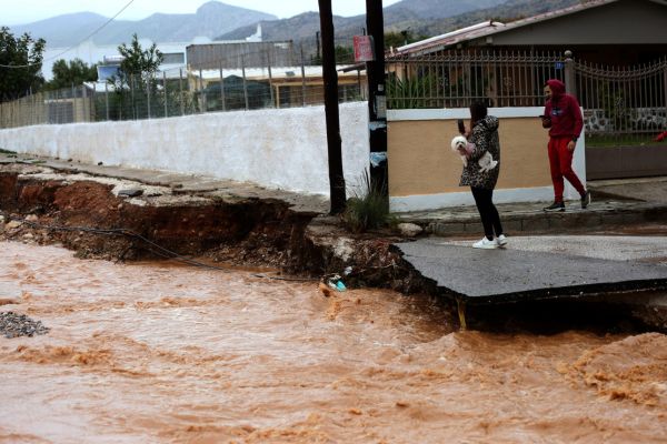
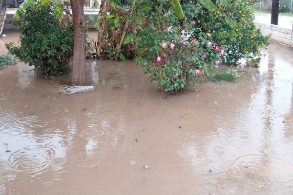
Byron is the latest named Mediterranean storm, originating from a strong low-pressure system that swept across mainland Greece with force. In Attica, the system triggered heavy rainfall, intense lightning activity and severe local flooding. Areas such as Megara, Nea Peramos and Mandra were hit hardest.


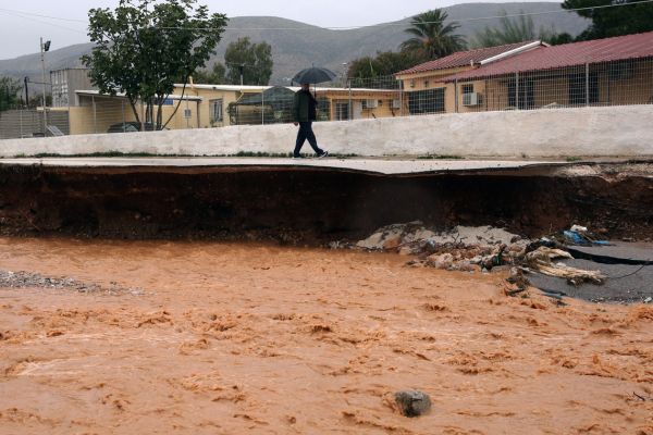
Emergency alerts were issued repeatedly through the 112 system, urging residents to move from basements and ground floors to higher levels as floodwaters rose. Roads were submerged, trees fell and major travel disruptions followed. Sections of the Athens–Corinth national road were closed, while the fire service responded to more than 230 calls for flooded homes, trapped citizens and fallen trees.


Rescue operations intensified in Laconia and the municipality of East Mani, where EMAK teams carried out back-to-back evacuations from flooded houses and vehicles. In Skala Lakonias, three people were pulled to safety moments before their vehicle, surrounded by rapidly rising water, became completely submerged. Dramatic footage published by Greek weather services shows rescuers battling strong currents and low visibility to reach those trapped.


What to expect in Cyprus as Byron approaches
A strong high-pressure system currently influences Cyprus, but conditions will begin to change as Byron approaches from the west. The low-pressure system is expected to reach the island from Friday night, bringing increased cloud, dust and the potential for local rain.
Today, weather conditions remain partly cloudy with isolated showers. Winds will range from moderate to strong, mainly northeast to southeast, reaching 4 to 5 Beaufort and temporarily up to 6 Beaufort in some areas. Seas will be slight to moderate. Temperatures will rise to around 23 degrees inland and along the coasts, and 12 degrees in the higher mountains.
Tonight, skies will be mostly clear with occasional cloud. Winds will weaken to 3–4 Beaufort, though exposed coastal areas may experience stronger gusts. Temperatures will drop to 9 degrees inland, 15 at the coasts and 5 in the mountains.
Tomorrow starts partly cloudy but will gradually turn mostly cloudy, with localised showers possible. Winds remain moderate to strong at 4–5 Beaufort. Temperatures will reach 21 degrees inland, 22 at the coasts and 11 degrees in the higher mountains.
Tomorrow night, clouds increase further, with expected local showers and isolated thunderstorms, mainly in the western half of the island. Seas remain slight to moderate.
Weekend forecast: Byron’s full impact
On Saturday the weather becomes mostly cloudy, and from midday onwards local rain and isolated storms are expected. Snow or sleet may fall on the highest Troodos peaks during the night.
Sunday and Monday will remain mostly cloudy with local rain and isolated thunderstorms. Snow or sleet could continue on Troodos peaks. By Monday, temperatures will drop to near or slightly below average for this time of year.
Authorities advise the public to stay updated as Byron approaches, particularly given the severe disruption already recorded in Greece.